![]()
Harking back: Tracing our heritage to the Lahore that was By Majid Sheikh Dawn, Sep 26, 2015
In the history of Lahore, which carbon-dating from the Lahore Fort tells us was functioning in the year 2,500BC, what did the city look like after the Afghan invader Mahmood flattened it in the year 1021AD? This is a question that will one day be answered by scholars of Lahore, and will hopefully add to our understanding of how the walled city evolved over time. This piece is an attempt to understand the building blocks as we understand them today. Over the last 1,000 years the city has had three major rulers who have contributed more to defining the walled city than anyone else. These three persons are the Hindu Shahi ruler Raja Jaipal (964-1,001AD), the Moghal emperor Akbar (1542-1605) and the Sikh ruler Maharajah Ranjit Singh (1780-1839). Under these rulers Lahore expanded and was at its most prosperous. Between Raja Jaipal, who committed ‘Johar’ outside Mori Gate at the southern side, to Maharajah Ranjit Singh, who was cremated outside the northern end, we have three major rebuilding efforts of the city. There were certainly others who contributed, more so damage control after invasions or strife, but never on the scale that these three great rulers did. Let us start this exercise so as to understand what the city looked like when the Afghans struck Jaipal. Just to clarify that this great ruler’s empire stretched from Kashmir to Multan and from the Sutlej to Kabul. His initial capital was Peshawar, and when he lost that to the Afghans he removed the local Lahore ruler Raja Bharat, who had conspired to assist Mahmood, and rebuilt Lahore and made it his capital. Our understanding of the walled city is best served if we follow two major markers. Firstly, are the ‘ghattis’ over where once stood the outer walls. Secondly, is the terrain of the mounds inside the city. The ‘ghattis’ determine the outer perimeter, and the mounds inside determine the street positions. Let us follow three alignments inside the walled city which have developed because of the mounds. Firstly, if we observe Waachowali Bazaar we see it emerge from the curvature of Gali Pir Bola. This is a major mound. Next, and by far the most important, is Suttar Mandi inside Lohari Gate. Just follow Mohallah Challaywala Hammam in Maachi Hatta Guzar onto Chowk Chakla, the original ‘red light’ area of the city, and on to Lohari Mandi. From this emerges a third mound of Chowk Mati as it moves and merges with Paapar Mandi. At this point we have the oldest gateway of Lahore, the Lohari Gate, and inside immediately we have Mohallah Maullian, probably where the very first city of Lahore, then called Lohar Kot, with the mohallah probably termed as ‘kacha kot’ if we are to believe H.P. Blavotsky’s Glossary of Sanskrit words. Mind you the over-riding fact remains that the slope of the land when seen from the Lahore Fort is that the gradient lowers as we head southwards, for the river flows because of this gradient. Around these mounds Lahore had come about thousands of years earlier, a safe place when the raging Ravi flooded the plains every year. Raja Jaipal reinforced and thickened the outer walls. If you walk along Bazaar Hakeeman you will notice, to the east, a ‘ghatti’ running all the way to Chowk Hira Mandi. If you enter Shahalami Bazaar you will see a ‘ghatti’ to the west all the way near Chowk Rang Mahal. This was the outer perimeter and where the walls once stood. So what did the walled city look like then? Research tells us that it only had two gates (or maybe three) and a ‘mori’. First, the ‘mori’. Lahore was then a pure Hindu city. Before the Hindus took over it was a Buddhist, as well as a Jain city, and we have enough clues that tell us that Gautam Buddha also visited the city on his way to the Taxila University, then the centre of the Harappa Civilisation. Who built the ‘Mori’ of Lahore? The answer to this lies in the Hindu rite of cremation of their dead. Cremation was not part of the initial Harappan people, for their dead were buried along with food and pots and pans for the ‘next world’. The emergence of the belief that souls returns in new shapes and life-forms led to cremation as a way of life. This is true of other civilisations too. Hence the need for a special gateway out of the walled city. Logic tells us that this ‘mori’ was an addition to the mud-walled city with the emergence of the Hindu faith. Mind you Hinduism is an evolving religion, and it might come as a surprise (with no disrespect intended) that human burial, and cow meat-eating to celebrate marriages, was the norm in the very initial period of its evolution. The Rig Vedas have described these major changes in some detail, which came about with the creation of castes, a sort of vegetarian Aryan feudalism. The initial ‘mori’, so accounts tell us, was barely four or five feet in height (nine hand lengths). In the grounds outside Mori Gate the dead of Lahore were cremated and their ashes consigned to the Ravi. It was here that Raja Jaipal committed ‘johar’ as a mark of honour over his failure to stop the Afghan hordes of Mahmood. So we can assume, safely, that this ‘mori’ is not more than 2,000 years old. The walls of Lahore had just one gateway to the south, and that being Lohari Gate. Experts believe that this is the city’s oldest gateway, probably over 4,500 years old. The wall to the west always was without a gate, and went on to curve and meet the northern gate. We must understand that the wall turned in before where today stands Taxali Gate. It passed where today stands Paniwalla Talab and immediately curved in to the east of today’s Shahalami Bazaar. The ‘ghatti’ to the east of the bazaar is ample proof of this, for under it lays the foundations of that original mud wall. This means that all the gateways to the east of Lohari Gate did not exist, except for Delhi Gate which was not in its present position, but was located at the north-eastern tip, which also saw the road from the west, or from present-day Sheikhupura, join it as it headed towards Delhi. Hence we see Lahore with just two gateways. But then this gives rise to the question of how did the rulers living in the fort enter the walled city. Here we have two possibilities. One being that they used the north-eastern gateway because the river enveloped both the fort and the walled city, and it makes sense, at least for a much smaller Lahore, to have the minimum of outlets. The other possibility, and one that a lot of researchers ascribe to, is that a third gateway existed where today stands Chowk Tibbi. By this account we have gateways to the south and to the north-east and north-west tips. What their names were I will not venture to say, at least not till research educates us. We know from several accounts that Malik Ayaz, the slave Governor of Mahmood, was buried outside the city walls. That grave today is in the middle of Chowk Rang Mahal. To learn about our past there is a lot of archaeological work needed inside the walled city to uncover our real history. Maybe once we have crossed the point where scholarship matters more, like our Harappan heritage, we will be able to see what the Lahore of Raja Jaipal was really like.
|
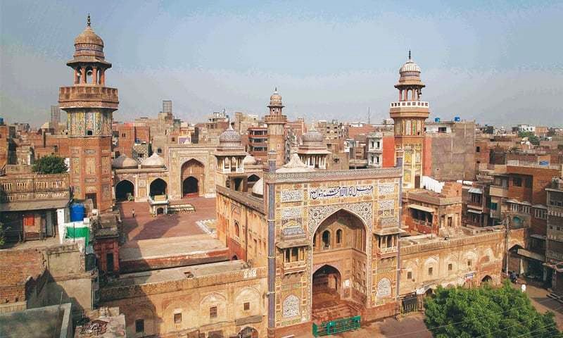 To learn about our past there is a lot of archaeological work needed inside the walled city to uncover our real history. —Zerka Tahir